


The United Nations General Assembly has backed a new world map designed to give a more accurate picture of the size of Africa and other continents.
The resolution, spearheaded by Togo and backed by African countries, was adopted on Friday with 164 countries voting in favour. The United States was the only country to vote against it, while six countries abstained.
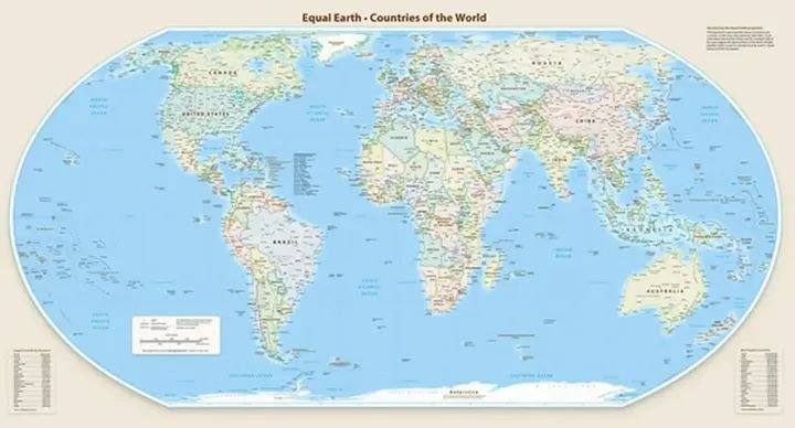
The move promotes the Equal Earth projection, which more accurately represents the relative sizes of the world’s landmasses than the traditional Mercator projection.
The Mercator map, created by Flemish cartographer Gerardus Mercator in 1569, was designed primarily for maritime navigation. However, it makes areas closer to the poles appear disproportionately large while shrinking regions around the Equator, including Africa and South America.
Under the Equal Earth projection, Africa appears significantly larger, while North America and Europe appear smaller in comparison.
Togo’s Foreign Minister Robert Dussey, whose country sponsored the resolution, said maps influence education and how people perceive the world.
“They are therefore never neutral; when they present a distorted image of our planet, they risk perpetuating inaccurate representation that is passed down through generations,” Dussey said.
The United States opposed the resolution, criticising the General Assembly for focusing on the map while major global challenges remain.
US representative Yaryna Ferencevych said such initiatives were “the reason this institution is losing its credibility”.
France, which co-sponsored the resolution, also announced that it would abandon the Mercator projection.
French Foreign Minister Jean-Noël Barrot said the traditional map gives countries such as the United States, Russia and China disproportionate visual prominence compared with Africa, Latin America and Southeast Asia.
“Changing maps obviously doesn’t change the world,” Barrot said. “But correcting a distorted representation is already an act of truth.”
The resolution is not legally binding, meaning countries are not required to stop using the Mercator projection. Instead, it encourages governments, educational institutions and others to adopt maps that better represent the relative sizes of continents.
The UN decision marks a major push by African countries to challenge what they describe as a long-standing distortion in the way Africa is visually represented on world maps.